
BlueConduit LSL Platform Tour
Proactively addressing water quality and the potential of lead service lines (LSLs) is an issue of public trust between utilities, local government, and individual households. Cities and water utilities need accurate, accessible data to identify LSLs and develop safe removal plans.
The EPA requires cities to submit LSL inventories and replacement plans by October 2024.
Make your inventory and replacement plan more accurate using BlueConduit’s statistical modeling and machine learning platform. With BlueConduit, your utility will reduce cost, increase efficiency, increase equity, and support healthy, thriving communities.

Develop your Inventory
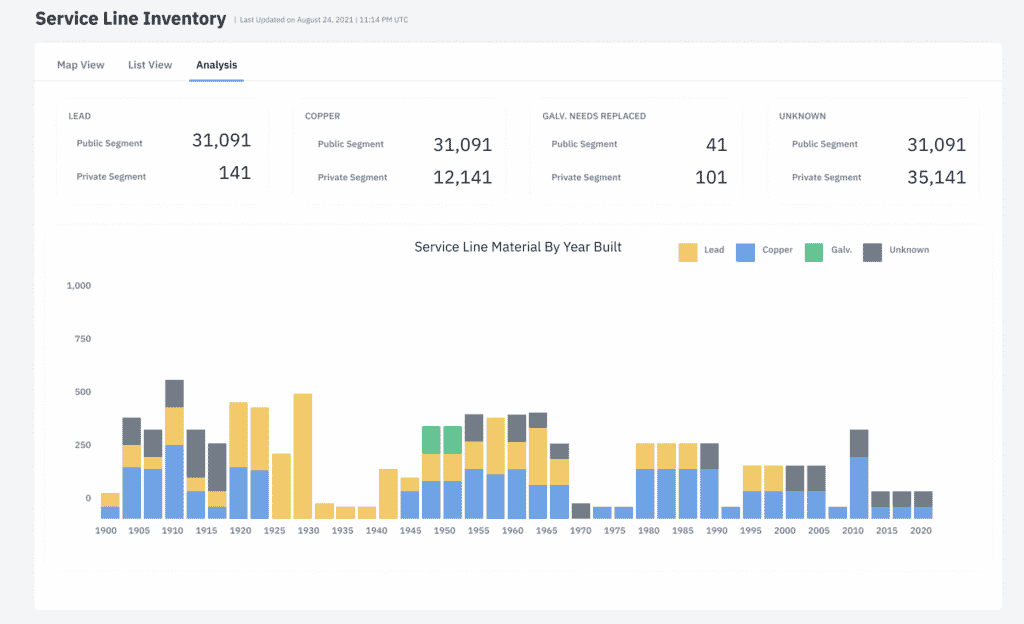
Digitize and Centralize your Service Line Inventory
Use BlueConduit’s centralized data management system to develop and maintain LCR compliant inventories. Upload spreadsheets, shapefiles, or tap cards to create a single source of truth for your lead service line replacement (LSLR) program in one easy-to-use platform.
Prioritize Lead Replacement
Develop a Robust Lead Service Line Replacement Plan
Leverage BlueConduit’s SaaS tool and industry expertise to build and execute your LSLR plan. Our robust, data science-based approach to LSLR optimizes efficiency, equity, and public health. Our >80% hit rate has driven millions of dollars in savings for cities and towns across the United States.
Manage Lead Replacement Field Work
Use our cloud-based inventory data management tool to collect, record, and update data from the field as you inspect service lines, repair assets, and replace lead pipes. BlueConduit’s cloud-based solution maintains an accurate, comprehensive service line inventory so you can monitor program costs and track progress toward your LSLR goals in real-time.

Simplify Compliance
Generate Required Reports with Ease
Compile and submit accurate LCR compliance reports with the click of a button. Meet all state LCRR requirements, from comprehensive service line inventories to compliance sampling.
Build Consumer Confidence
Distribute Resources Equitably
Lead service lines are most prevalent in communities with lower incomes, more renters, and more minority residents. Leverage our debiasing technology and the latest demographic and socioeconomic indicators to prioritize the communities at the highest risk of lead exposure.
Communicate Progress
BlueConduit’s user-friendly, online maps are developed in collaboration with experts in public health communication to give community members a clear picture of their individual risk and help utilities maintain trust and transparency with customers.

ArcGIS Integration
Utilities can access their smart service line inventory predictions and lead service line replacement priorities from BlueConduit within their Esri ArcGIS Online environment.
BlueConduit is an Esri Silver Partner and has achieved the System-Ready designation.
Read more about our Esri Integration, find us on the Esri Marketplace, and check out our joint case study with Cary, North Carolina.
Not on ArcGIS? No Problem
Utilities not on ArcGIS Online can still get their predictions, maps, and reports directly.